Other Storm Chaser Accounts For February 01, 2011
Storm Chasing Blog
Chase Target:
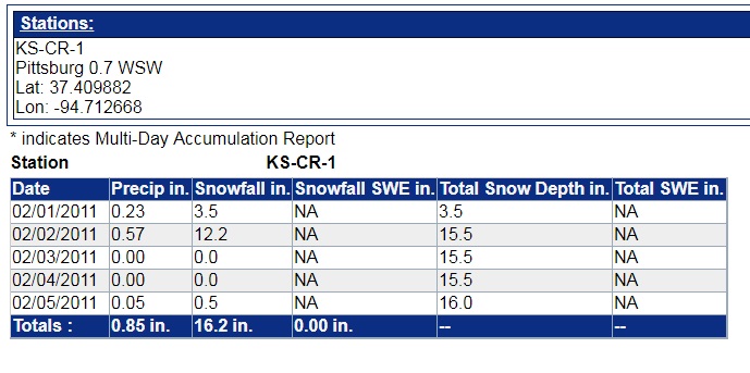
Pittsburg, Kansas
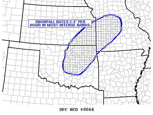
SPC Mesoscale Discussion
At 3:11 AM CDT On
February 01, 2011
CoCoRaHS Snowfall Total
For This Blizzard Event
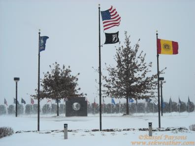
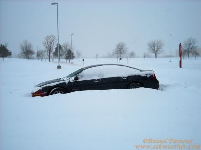
25-35 MPH Winds Caused Blizzard Conditions In Pittsburg, Kansas
Snowfall Totals Of 12.2" In Southeast Pittsburg, Kansas Shut Down The Town
No articles have been located about this event!!
NONE FOUND!
These will be added when time permits...
To View The Entire Photo Album Of This Event, Please Click Here (Clicking The Slideshow Is The Best Option)
PHOTO GALLERY
NEXRAD WEATHER RADAR IMAGES
STORM PREDICTION CENTER CONVECTIVE OUTLOOK FOR THIS DAY
STORM REPORTS FOR THIS EVENT
NEWSPAPER ARTICLES AND OTHER STORM CHASER ACCOUNTS
Newspaper Articles For February 01, 2011
Storm Intercept Summary
Today was pretty much an interesting one weatherwise. Areas of freezing drizzle from the predawn hours into the afternoon hours on the 31st produced slick roads across Southeast Kansas. Thereafter, from the evening on the 31st through the evening on February 1st, areas of moderate to heavy snow produced anywhere from 10 to 14 inches snow accumulation across Southeast Kansas, with highest amounts over eastern portions of the area. Sustained north to northwest winds of 20 to 25 mph, with gusts up to 40 mph, produced blizzard conditions at times, along with extensive drifting. Additionally, temperatures in the teens in concert with the strong winds resulted in wind chill readings down to around -15 degrees.
Blizzard Conditions In Pittsburg, Ks.
February, 01, 2011
Tornadoes:
Funnel Clouds:
Wall Clouds:
Hail:
Flooding:
00
00
00
None
No